Global Soil trafficability with satellite data
Soil matters. This applies to farmers and builders, but certainly also to soldiers. If you misjudge the soil’s condition, heavy vehicles will get stuck and a military operation will go awry.
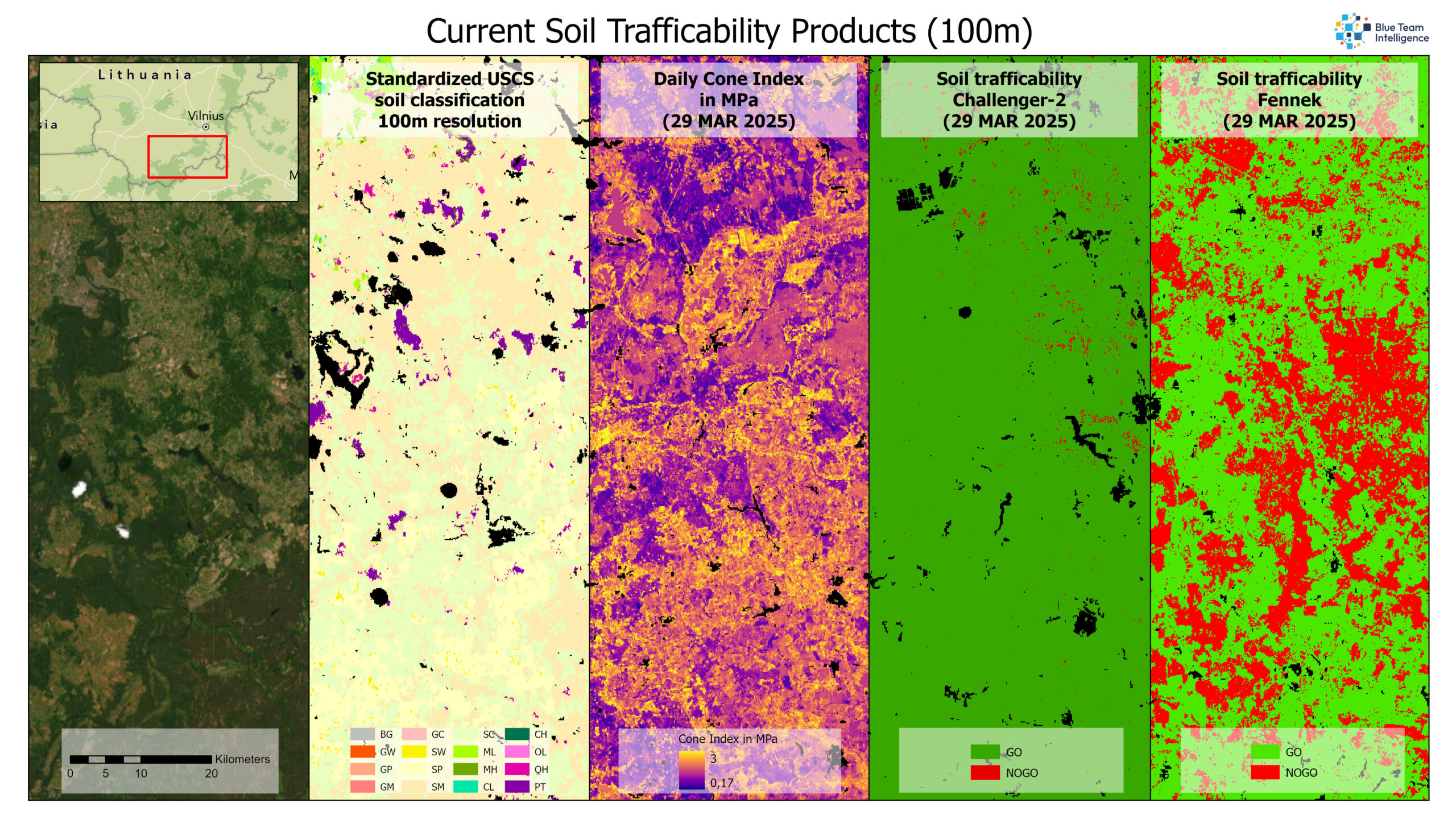
Blue Team Intelligence has developed a global Soil Trafficability product with 100-meter resolution based on satellite data. This product displays daily the soil’s daily carrying capacity based on the USCS classification and daily soil moisture. The soil trafficability can be determined daily for more than 100 vehicles. This is naturally useful for military applications, but it can also benefit civilian organizations, such as fire departments fighting forest fires or drivers who need to deviate from existing roads to reach their destinations.
This Soil Trafficability product will be available as a SaaS solution on the Planet Insights Platform, but will also be available as an On-Premise solution.
Soil and military operations
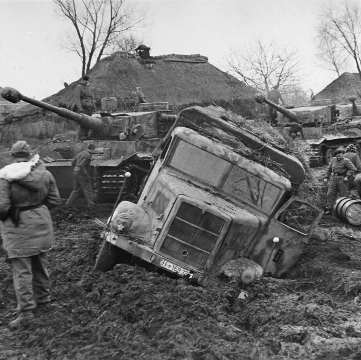
There are many examples from military history where underestimating the influence of the ground led to disastrous consequences. For example, during Operation Barbarossa in 1941, the German army became bogged down in the Russian mud. The Rasputitsa (mud season) turned roads into swamps, stranding vehicles and disrupting supplies. Underestimating this annual natural phenomenon slowed the advance to Moscow and gave the Soviets time to regroup.
Even in modern times, we see that soil conditions significantly impact the mobility of heavy combat vehicles. This time, it’s Russian troops in Ukraine who suffer heavy losses due to the same Rasputitsa. The freezing or thawing of the topsoil of the highly organic soil turns the ground into muddy sponges where heavy vehicles sink deeply and come to a standstill. This makes them easy prey for drones and artillery.

In battle, armies want to make the best possible use of their weapons. For combat vehicles, this means they want to gain speed and deploy as widely as possible. Only this way can you overwhelm the enemy and maximize your combat power. But you can’t simply rush through the entire terrain. Every soldier knows the famous saying: “The terrain dictates.” Various aspects of the terrain completely determine how armies can deploy their resources. Commanders who carefully analyze the terrain and adapt their actions accordingly have a greater chance of winning the battle. They can also use the terrain to predict the enemy’s plan. A good terrain analysis is therefore vital.
The terrain dictates
In modern warfare, speed is more important than ever. Due to the increasing use of OSINT and satellite data, enemy movements are constantly monitored, and the chance of surprise is diminishing. To maintain initiative in combat, commanders must make sound decisions quickly and effectively in response to the changing situation. Whoever does this fastest maintains the initiative and has the best chance of victory.
Within NATO, tactical army staffs use a standardized and consistent tactical decision-making model: Tactical Planning of the Land Forces (TPLF). This allows troops from different countries to collaborate quickly and use the same procedures and formats. Terrain analysis is a key part of this process.

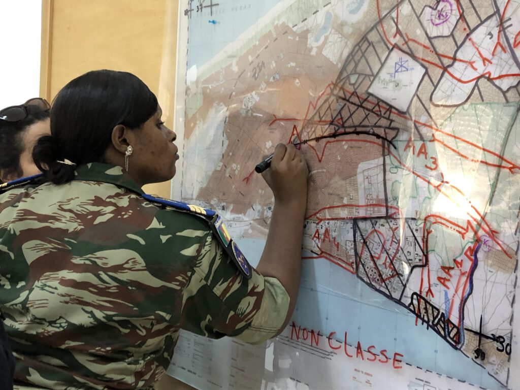
A large part of the terrain analysis is currently done manually from the topographic map. This is a slow process and highly dependent on the speed and mental condition (e.g., lack of sleep) of the staff officer. Furthermore, much information about the soil is not described on the map. Therefore, the influence of the soil is not optimally analyzed in the terrain analysis.
To determine the soil’s load-bearing capacity, the expertise of the Engineers is utilized. They take soil samples and, based on field tests, determine the soil’s properties, or they determine the ground pressure using a penetrometer. This process is time-consuming and, given the current threats on the battlefield, extremely dangerous. Moreover, ground pressure is highly dependent on temporal factors such as precipitation and evaporation and can change drastically within a few days.
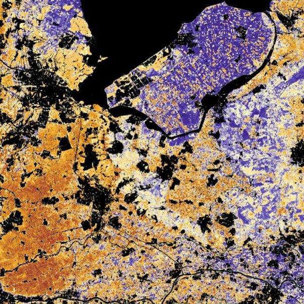
Unified Soil Classification System (USCS)
A good method to identify the soil’s load-bearing capacity is by classification based on physical characteristics. There are multiple classification methods, but the most frequently used within NATO is the Unified Soil Classification System (UCSC) This method divides soil in 15 classes, based on the distribution of grain size, organic matter content, liquid limit and plasticity index. The distribution of these classes is relatively simple. However the properties are hard to determine. A lab environment is required, when this is unavailable, field tests are used.

The USCS provides a good representation of the potential bearing capacity of the soil, and good studies have been conducted on the maximum soil pressure based on the USCS classification and the percentage soil moisture.
Unfortunately, few datasets and maps are available for Europe and potential conflict zones based on the USCS classification. High-quality soil maps are available for a few countries, but these are often classified for different purposes and are difficult to translate to the USCS classification. Together with Cohere Consultancy, we have translated the Dutch soil map to the USCS classification. However, some classes remain difficult to translate, as the USCS is based on soil behavior, which can sometimes differ from compositional data.
Our solution: Automated soil trafficability
The lack of reliable soil data in military operation planning calls for faster and more accurate methods to determine the soil’s bearing capacity and behavior. The Earth is continuously monitored by satellites that observe the characteristics of our planet across the full spectrum of the electromagnetic spectrum. By combining long-term satellite data with existing soil datasets, it is possible to accurately predict the subsurface’s characteristics and translate these into the USCS classification and soil pressure.
Blue Team Intelligence has spent the past six months developing a global solution for ground accessibility with a 100-meter resolution, based on satellite data. This product predicts current ground pressure and translates this into ground accessibility for more than 100 different Western and Russian military vehicles. Every single day.
“Soil trafficabillity for every vehicle, anywhere in the world, every day of the year”
Soil trafficabillity primarily concerns ground pressure: How much pressure can the ground currently withstand, and is it then capable of supporting the weight of a particular vehicle? And what if multiple vehicles drive over this surface?
The answer to this largely depends on a number of semi-permanent and temporal factors.
The semi-permanent factors
A key factor in soil load-bearing capacity is its composition: the ratio of gravel, sand, silt, clay, and organic matter. This composition determines how the soil handles plasticity and its yield point. The USCS classification can be determined based on the combination of these factors.
The ratio of physical elements in the soil is revealed by several indicators and factors. For example, the way the soil handles moisture reveals its potential composition, but also the geological history, the elevation relative to its surroundings, the way the soil is used, and the vegetation that grows on it. Based on scientific publications, we have developed a model that identifies 10 groups of key factors and indicators that explain the soil’s composition.
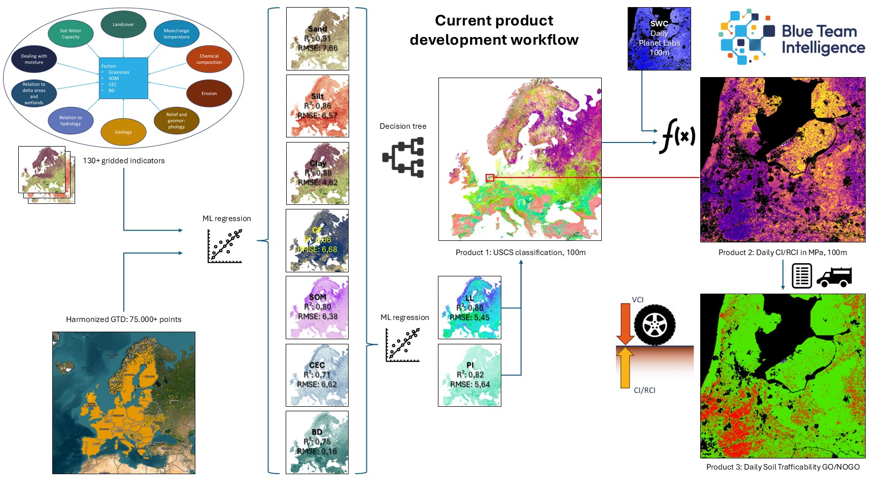
We translated this model, containing the key factors and indicators, into more than 130 globally available grids that potentially contain these factors and indicators. Some of these grids are already published, freely available datasets. A good example is the SoilGrids dataset. These datasets, carefully developed by ISRIC, offer very high-quality predictions of soil elements at various depths. These datasets are the best, freely available soil grids available to date, but are too coarse-grained and, in many locations, too inaccurate for determining soil accessibility. The SoilGrids data does, however, significantly strengthen the final prediction model.
We developed other grids ourselves based on theoretical relationships between soil characteristics and underlying factors. For example, we used derivatives of a globally available elevation model to determine the Terrain Roughness Index and Terrain Wetness Index, but we also developed a grid that shows the cost distance to the nearest wetland or stream, where the elevation difference represents the degree of resistance.
Simultaneously, we collected and harmonized multiple global, regional, and national soil sample datasets. This created a Ground Truth dataset with over 200,000 available points containing laboratory-measured data from the first 30 cm of soil.
Based on the rasters and ground truth data, we trained machine learning regression models that predict the extent of several crucial factors for determining the USCS classification. These factors include the percentages of sand, silt, clay, gravel, and organic matter, as well as the Cation Exchange Capacity (CEC) and bulk density (BD). Tests show that our developed models predict these factors with a high degree of accuracy.

By combining the globally predicted values of these 7 factors, we have classified every pixel of the Earth according to the USCS with a high degree of confidence.
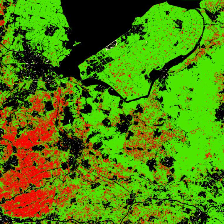
Temporal factors
But soil pressure isn’t solely dependent on soil composition. The amount of soil moisture in the soil also plays a significant role. Unlike soil composition, this data is temporal and constantly changing due to factors such as precipitation, evaporation, infiltration, freezing, and vegetation uptake. Passive radar satellites, such as SMOS and SMAP, record moisture in the Earth’s surface and vegetation, but their resolution is insufficient for our model. Fortunately, Planet Inc. has developed a model to translate this data into a high-quality soil moisture product with 100-meter resolution. By combining this Soil Water Content (SWC) with the USCS-classified pixels, the soil’s bearing capacity can be determined per pixel. For this, we use a model partly developed by the US Army Engineers Corps and partly derived from our own field tests. This combined model accounts for the worst-case scenario under wet conditions, as well as under extremely dry conditions.
The Cone Index (CI) is a widely used measurement standard. This measurement is determined by pressing a penetrometer cone evenly into the soil. The amount of pressure exerted can be translated into soil pressure. Our model allows us to predict the Cone Index in Mega Pascals (MPa) daily under the worst soil conditions, based on the USCS combined with the soil moisture percentage. This is without anyone having to be physically present in the field.
When multiple vehicles drive over the same area, the ground is disturbed, which reduces ground pressure. The ground pressure under these altered conditions is called the Remolded Cone Index (RCI). We have also developed a combined model for these conditions.
At Blue Team Intelligence, we’ve calculated the ground pressure of over 100 military and civilian vehicles based on their characteristics. This ground pressure, expressed in MPa, is called the Vehicle Cone Index (VCI). By comparing this VCI with the daily CI for each pixel, we can determine where each vehicle type can and cannot drive based on the ground pressure.
We have made a demo of our product available in a web app, which can be accessed via the following link.
What’s next?
Our initial 100-meter product is currently only available for Europe and Western Russia, but its development leveraged globally available data. This makes the product scalable, and we’ll be adding more regions in the coming months, starting with Africa and Asia.
We will also resample the 100-meter product to 30-meter resolution by combining it with higher-resolution satellite and elevation data.
Currently, the near-real-time Cone Index is determined daily. While this already provides good insight into ground conditions for future operations, we want to take this a step further by predicting the Cone Index up to seven days into the future. This will allow for even better decisions to be made for future operations.
In addition, current models determine the Cone Index based solely on soil moisture. We will develop new models that also consider other temporal factors, such as soil temperature and the degree of compaction due to land use.
Finally, we want to add more vehicle VCI to our list, but we also want to look at other ways to relate vehicle off-road capability to the ground, so that we can determine even more precisely where a vehicle can drive.
Interested?
Our current and future Soil Trafficability product is valuable for Western NATO-aligned militaries, as well as for various public and commercial organizations. If you are interested in our product, please contact Bas Ooink at bas.ooink@blueteam-intelligence.nl